Communick News
  • Communities
  • Create Post
  • heart
    Support Lemmy
  • search
    Search
  • Login
  • Sign Up
infeeeee@lemm.ee to OpenStreetMap community@lemmy.mlEnglish · 1 year ago

The OSM Iceberg by Xvtn

i.postimg.cc

message-square
9
fedilink
78

The OSM Iceberg by Xvtn

i.postimg.cc

infeeeee@lemm.ee to OpenStreetMap community@lemmy.mlEnglish · 1 year ago
message-square
9
fedilink

From Xvtn’s diary

alert-triangle
You must log in or register to comment.
  • Potatos_are_not_friends@lemmy.world
    link
    fedilink
    English
    arrow-up
    13
    ·
    1 year ago

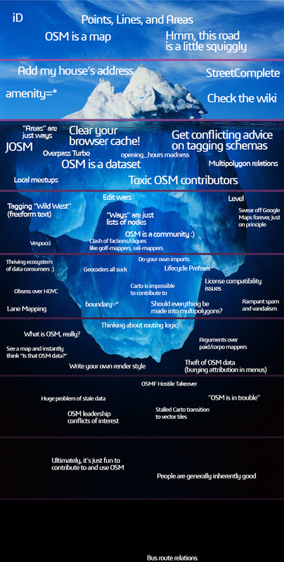
    This picture a metaphor for so many of the bigger open-source projects. I love it.

  • Rozaŭtuno@lemmy.blahaj.zone
    link
    fedilink
    English
    arrow-up
    13
    ·
    1 year ago

    What’s the matter with bus routes?

    • infeeeee@lemm.eeOP
      link
      fedilink
      English
      arrow-up
      15
      ·
      edit-2
      1 year ago

      My problem is that they are broken. Like a lot of them. Most of them.

      Here are all the broken routes on OSMI. Just zoom in anywhere. (this also shows other means of transportation, but most of them are bus routes)

      A lot of users don’t understand them, ID editor’s support of them is minimal, so a lot of users accidentally break them, and they don’t even understand what is the problem, because they can’t see them in ID.

      Fixing them is not easy, and time consuming. There is no easy way to batch edit them, so if someone messes up a roundabout, you have to fix all bus lines one by one. OSM Relatify helps somewhat with that, but it has its own limitations, and you still have to edit them separately.

      • redd@discuss.tchncs.de
        link
        fedilink
        English
        arrow-up
        3
        ·
        edit-2
        1 year ago

        same for hiking and biking routes. I found some obvious errors but I am not able to fix it with ID. I created some notes for them but since several monthes nobody fixed it.

        • mcliquid@en.osm.town
          link
          fedilink
          arrow-up
          2
          ·
          1 year ago

          @redd @infeeeee we need just more people working with JOSM :josm: @josmeditor

          • redd@discuss.tchncs.de
            link
            fedilink
            English
            arrow-up
            3
            ·
            edit-2
            1 year ago

            JOSM is designed to be used on a Computer with keyboard and mouse. Therefore I assume your wish will not come true.

            Perhaps we need to wait until there are mobile app which can be used to fix all the hiking, biking and bus relations. (I tested Vespucci and its horrible for relation fixing)

  • 𝗧𝗼𝗮𝘀𝘁𝗲𝗿 *𝑣𝑒𝑟𝑦 𝑝𝑢𝑠ℎ𝑒𝑑 𝑑𝑜𝑤𝑛@slrpnk.net
    link
    fedilink
    English
    arrow-up
    9
    ·
    1 year ago

    Can anyone tell me more about the OSMF hostile takeover?

    • Amᵃᵖanda 🔜 KA Hackwkend@en.osm.town
      link
      fedilink
      arrow-up
      9
      ·
      1 year ago

      @toaster @infeeeee There’s been about ~4 or 5 attempts IIRC.

      This one is well documented: https://wiki.openstreetmap.org/wiki/GlobalLogic

  • VitulusAureus@lemmy.world
    link
    fedilink
    English
    arrow-up
    6
    ·
    1 year ago

    This is incredibly accurate.

OpenStreetMap community@lemmy.ml

openstreetmap@lemmy.ml

Subscribe from Remote Instance

Create a post
You are not logged in. However you can subscribe from another Fediverse account, for example Lemmy or Mastodon. To do this, paste the following into the search field of your instance: !openstreetmap@lemmy.ml

Everything #OpenStreetMap related is welcome: software releases, showing of your work, questions about how to tag something, as long as it has to do with OpenStreetMap or OpenStreetMap-related software.

OpenStreetMap is a map of the world, created by people like you and free to use under an open license.

Join OpenStreetMap and start mapping: https://www.openstreetmap.org/.

There are many communication channels about OSM, many organized around a certain country or region. Discover them on https://openstreetmap.community/

https://mapcomplete.org/ is an easy-to-use website to view, edit and add points (such as shops, restaurants and others)

https://learnosm.org/en/ has a lot of information for beginners too.

Visibility: Public
globe

This community can be federated to other instances and be posted/commented in by their users.

  • 3 users / day
  • 160 users / week
  • 500 users / month
  • 1.39K users / 6 months
  • 2 local subscribers
  • 4.73K subscribers
  • 361 Posts
  • 2.27K Comments
  • Modlog
  • mods:
  • Ben_on_Lemmy@lemmy.ml
  • pietervdvn@lemmy.ml
  • m-p{3}@lemmy.ca
  • SyJ@lemmy.ml
  • BE: 0.19.9
  • Modlog
  • Instances
  • Docs
  • Code
  • join-lemmy.org